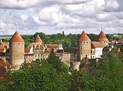
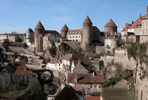
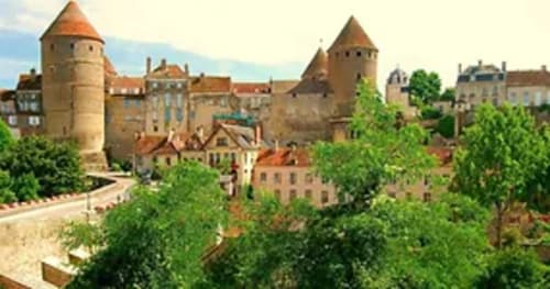
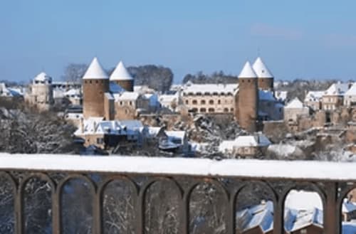
Semur-en-Auxois
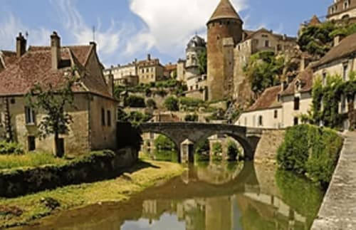
Emerging from a loop in the Armançon River, Semur-en-Auxois stands proudly on its pink granite plateau.
The town is located in the largest of the 4 valleys that make up the Auxois region, at the crossroads of the Morvan foothills, the Châtillonnais plains and the outskirts of the Autunois.
A centuries-old settlement, legend has it that Semur was built by Hercules on his return from Spain.
Over the centuries, Semur developed to such an extent that in 1276 it was granted its charter of Freedom by the Duke of Burgundy, Robert II.
The town came into its own in the mid-14th century, during the Hundred Years' War, when it was decided to reinforce the site's natural fortifications with enclosures scattered with towers and an imposing keep directly dividing the castle from the town.
A stronghold of the Auxois region, Semur was loyal to the Dukes of Burgundy, to the point of opposing royal authority. It paid a high price for this position when Louis XI's troops invaded the town in 1478.
In 1589, Semur suffered its final siege. During the wars of the League, the town was subdued by Marshal de Tavannes. Henri IV ordered the dismantling of the fortifications in 1602.
The town lost its defensive role and became the capital of the Auxois baillage, with all its attendant prerogatives (presidial, salt storehouse, etc.).
The town's political, religious and economic influence is undeniable; these three poles of society have stigmatized the area and are clearly visible in the town's buildings, with its district of fine residences, its collegiate church, its small properties clinging to the steep, harmonious curves of the granite promontory and blossoming around the banks of the Armançon.
Rue Buffon
Built in the 15th century, this front gate with its three rows of corbels, pierced by fire hydrants, has a certain aesthetic appeal.
A little further on, on Rue Buffon, we come to the Porte Sauvigny.
Built around 1447, you can still see the grooves where the arms of the drawbridge spanned a moat.
Next to it, you can also see the site of the pedestrian footbridge that opened onto a door with straight chamfered feet between the two buildings. From the end of the 15th century, this gateway housed the auditorium of the bailiff's court; despite its defensive function, it has a certain elegance with its pepperpot towers. The town's coat of arms can also be admired: the ducal crown is a reminder that Semur was attached to the Duchy of Burgundy, while the imposing tower evokes the town's defensive role.
The Semurois "motto" ("les Semurois se plaisent fort en l'accointance des estrangers") can be seen on the vault between the two gates, taken from F. de BELLEFOREST's Cosmographie Universelle of 1575.
we then pass under the Porte Guiller, which was the most important entrance to the town before the construction of the Porte Sauvigny. Named after a wealthy burgher living in Semur in the early 15th century, it has been known by this name since 1411.
The building displays a certain austerity, the only ornamentation being the geminated windows with carved colonnettes supporting three-lobed lintels and the supporting heads on each floor.
In the corner, a strange, saucy sculpture is hidden, naughtily combining the forms of a mermaid and male attributes.
The Renaissance tower, with its glazed tiles, was home to the Governors of Semur before they relocated to the château.
The façade still bears the street's former name, given in 1791 at the time of the Constitution: rue Jean-Jacques.
Opposite, a beautiful 13th-century staircase turret features two sculpted heads: Jean qui pleure and Jean qui rit, in other words, rain and shine.
Looking down rue Buffon, you can see a facade of tufa stone, a relatively rare material in the region.
If you turn around, you'll see a sundial on one side, and next to it a monstrance with the Latin phrase "the sun shines for everyone". On the other side is a well surmounted by beautiful ironwork.
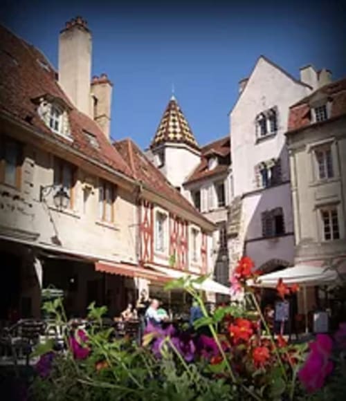
A rich district if you look at the buildings.
The houses are built of fine Renaissance and 18th-century freestone, with artistically crafted dormers that vary from one house to the next. Some buildings still have remarkable gargoyles.
A door lintel still bears the inscription: "Endurer et espérer. 1577 ".
We come to timber-framed or half-timbered houses. Made of cob (a mixture of straw and earth) and wooden beams resting on wooden corbels, as in house no. 26, or stone, as in house no. 28, the ground floors are of dressed stone. There are few half-timbered houses left in Semur, as in 1593, a terrible fire destroyed 270 houses.
On the right is the "Logis du Roi" (King's Dwelling), so named because tradition has it that King Henri IV spent a night here during his visit to Semur in 1602, the date of which is engraved above the door.
In 1561, the building was used as an auditorium for dispensing justice, and was successively occupied by the bailliage, the presidial court erected in 1696, the district court and, until 1844, the court of first instance. Considerably altered over time, its facade retains few traces of its original architecture.

Rue Varenne
In 1791, at the time of the Constitution, it was called "rue du Nord", as it can still be read in the stone at the intersection, just as "rue Jean-Jacques" indicates the present rue du Renaudot.
In a niche stands a statue of Saint Jean- Baptiste
on which traces of polychromy still remain, and next to it a stone figurine, the former base of a statue.
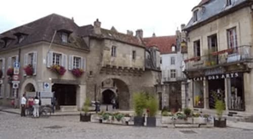
Place du Vieux Marché
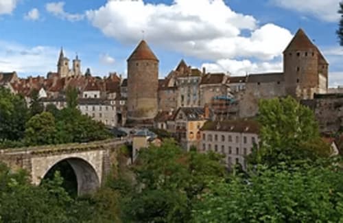
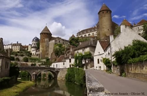
Le Donjon
The period of its construction remains rather vague, but we can accept Viollet-le-Duc's hypothesis that it dates back to the 13th century. Indeed, when part of the walls were repaired in 1354, the keep had already existed for some time, perhaps since 1276, the date of Semur's Charter of Freedom, and we can assume that the Duke continued to assert a certain authority over the town via the keep.
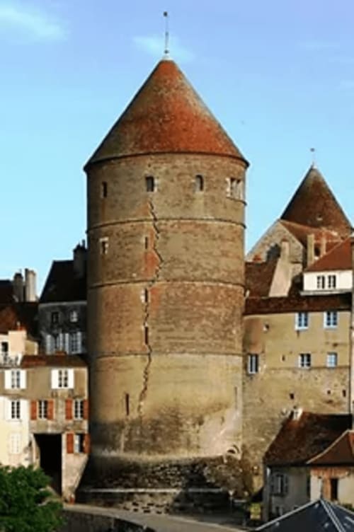
Composed of four imposing towers in terms of both height and width, the most important of which is the Tour Lourdeaul, now known as the Tour de l'Orle d'Or, with its 42-metre high walls measuring 5 metres at the base and 2.15 metres at the top. It is the master tower of the whole complex, as it also served as an access route between the Armançon districts (rue des Vaux) and the Donjon and Bourg.
Famous for its crack, many legends attempt to explain it. Quite simply, it was the dismantling of the curtain walls in 1602 that caused the crack.
Today, the Tour de l'Orle d'Or is the headquarters of the Société des Sciences Historiques et Naturelles de Semur (Semur Society of Historical and Natural Sciences), and houses a small museum with various collections, open from July 01 to August 31.
When the keep lost its defensive function, this tower became a prison until 1860. For this reason, a well-preserved section of curtain wall is still attached to it, serving as the guards' living quarters.
Behind the theater stands the Margot Tower. Formerly the salt store of the Auxois bailiwick, it was also used as a warehouse for the keep's artillery. This tower is currently used as a storehouse for theater sets.
Opposite is the tower of the Gehenna, meaning Hell or torture in the Bible. Also the salt granary of the Auxois bailiwick, you can see the traces left by the salt on the walls.
All the towers were covered, although there was a system of crenellations set into the overhang. Each tower was made up of four levels, the last of which was pierced by large openings to allow the installation of stilts.
Most of the curtain walls linking the towers have either disappeared or been converted into living quarters.
The curtain walls formed a crenellated walkway that served to keep watch over the various access routes to the site. They were lined with square towers, which can be seen on the map of Munster, and served as gates to the keep, preceded by ditches.
Given the narrowness of the site, the gates, curtain walls and towers were fitted out and habitable. A chapel, a market hall and a well, which can still be seen today, made the keep a place of retreat in the event of siege.
Turning around, we see a small alley at the end of which leads to the Fourneau stairs and one of the town gates linking the Armançon quarters with the Donjon and the Bourg. The name "Ecaliers du Fourneau" comes from the presence of a communal oven in the Middle Ages.
Rue Fevret
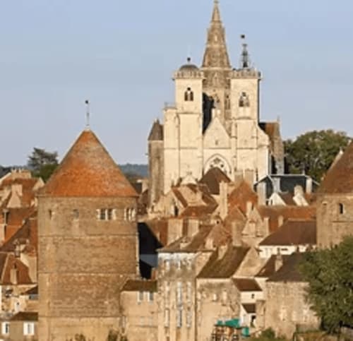
Place Notre Dame
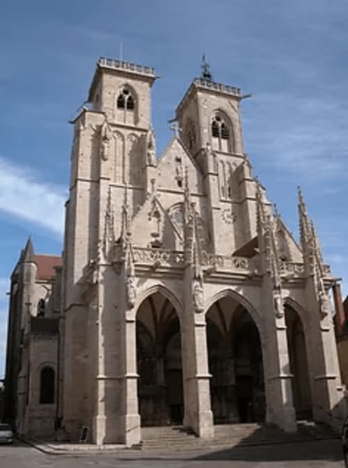
On this site stood a Romanesque church built in 1060 by Robert-le-Vieux, head of the first royal race of the Dukes of Burgundy, in atonement for the murder he had committed around 1031 against his father-in-law Dalmace I.
The new church was built from 1225 onwards, using Pouillenay limestone and a distinctive bluish Sinemurian limestone pavement with traces of gryphae and ammonites.
Both towers were damaged several times by fire and were rebuilt by Viollet-le-Duc in the last century. In the Barbe tower is the bell, which has been recast several times over the centuries. Next door is the clock tower. Above the forecourt, you can see the bell-ringers' houses. This privilege was granted to winegrowers, who paid an annual fee to ring the bells to announce the beginning and end of work in the vineyards and fields.
The church is accessed by 9 steps leading up to the forecourt.
A gate closed the forecourt, installed in 1729 at the instigation of Abbé Morel to prevent acts of vandalism. The hinges left by Viollet-le-Duc when he had the gate removed during the restoration of the church can still be seen.
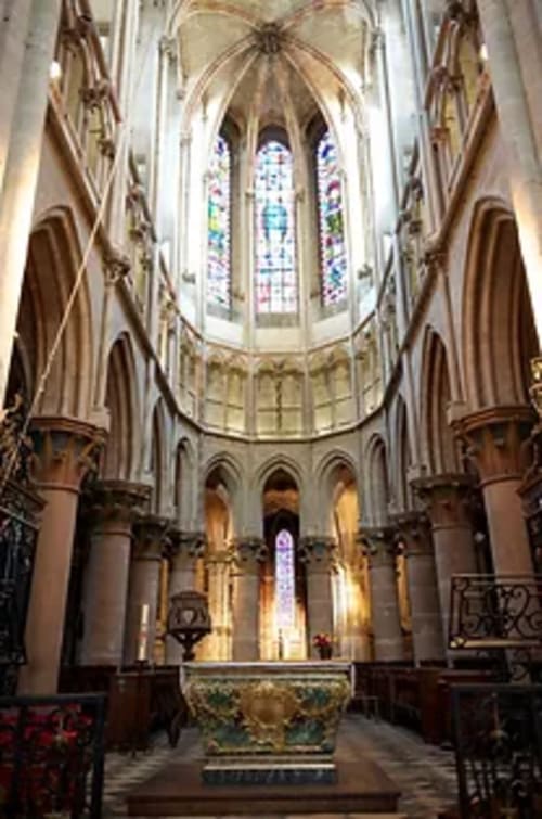
Entering the nave, it's important to note that the last three bays date from the end of the 14th century, when the church began at the cloister door.
This small cloister provided access to the priory where a small community of Benedictine monks lived.
The first chapel is of primitive Gothic design, to which Renaissance-style ornamentation has been added.
The sacristy features 18th-century oak panelling with portraits of the four Evangelists and the four Doctors of the Church (Saints Leo, Augustine, Jerome and Ambrose).
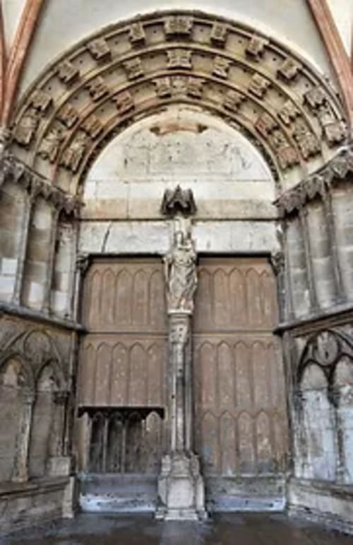
The Bleds Gate
The voussoirs depict the calendar, with the twelve months of the year symbolized by the work of the land. For December, we see a Janus opening and closing a door at the same time, evoking the year that is ending and the one that is beginning. Underneath, we see strange figures: a man dressed in foliage holding the arm of a monk, and next to him a figure seated atop a column like a stylite monk. On one of the columns, two snails evoke the symbol of Burgundian gastronomy. Also visible are the remains of a porch destroyed in 1705 to facilitate traffic! This porch probably provided access to an alleyway that joined Rue Buffon. A little further on, you can see a niche used for gas street lighting.